|
GPS Navigation Corridors Upgraded Prior To 9/11
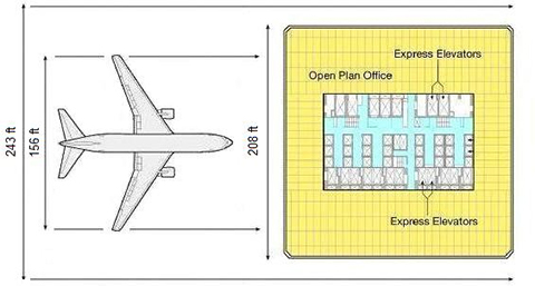
Pre-9/11 Upgraded GPS Service Provided 243 Foot Wide
Aerial Navigation Corridors
Submitted by Aidan Monaghan on Thu, 04/30/2009
- 5:04am
Enhanced GPS service (WAAS), now in use by
the U.S. commercial aviation industry and activated 13 months prior to the
terrorist attacks of September 11, 2001, provided virtual aerial navigation
corridors only 243 wide and a 95% confidence that an aircraft's true
position will fall within such a corridor . Such corridors can be navigated
entirely by autopilot and flight management systems scheduled in 1996 and
1998 to be contained by United and American airlines Boeing 757 and 767
aircraft like those used during the terrorist attacks of September 11, 2001.
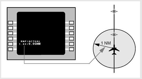
RNP .02 / Boeing
767-200 / World Trade Center Tower
WAAS also supports
required navigation performance (RNP) operations, says Raytheon,
providing a precision navigation capability down to RNP 0.02 (an
accuracy of 0.02nm).
http://www.flightglobal.com/articles/2003/01/07/159964/ups-wins-faa-cert...
RNP is a required
navigation performance level described by the specification of a
numeric value indicating the required navigation accuracy for a
specific operation, typically specified laterally in nautical
miles - e.g., RNP 1 is a Required Navigation Performance of ± 1
nautical mile (95% Probability).
http://www.airweb.faa.gov/Regulatory_and_Guidance_Library/rgAdvisoryCirc...
1 nautical mile = 6,076 feet
RNP 0.02 = RNP (0.02
nautical mile radius) x 2 = RNP (121.5 foot radius) x 2 = a 243
foot wide corridor
Boeing Example
(Boeing)
http://clacsec.lima.icao.int/Reuniones/2008/CE73/NE/BoeingPresentacionFT...
AMENDED VERSION: Wide Area Augmentation
System Signal Now Available
August 24, 2000
WASHINGTON, DC — After a successful 21-day
stability test of the Wide Area Augmentation System (WAAS)
signal in space, the U.S. Department of Transportation's Federal
Aviation Administration (FAA) declared that it is now available.
http://www.faa.gov/news/press_releases/news_story.cfm?newsId=5249
According to Raytheon’s director-satellite
navigation systems, the newly activated WAAS signal was used by
rescuers at New York City's Ground Zero site following September
11, 2001 in order to precisely survey the site:
And, at the World Trade Center, rescue
teams used WAAS to survey the site during the recovery program.
http://www.aviationtoday.com/av/categories/commercial/12571.html
By 1996 and 1998, United and American airlines
Boeing 757 and 767 aircraft, like those used during the
terrorist attacks of September 11, 2001, were scheduled to
contain flight management systems and signal receivers capable
of utilizing the new GPS service.
HONEYWELL ANNOUNCES ORDERS FOR
NEW-GENERATION "PEGASUS" FLIGHT MANAGEMENT SYSTEM
FARNBOROUGH, ENGLAND, SEPT. 7, 1998 - The
Honeywell "Pegasus" flight management system earned its first
FAA certifications March on the Boeing 757, 767 and MD-90
aircraft types ... Airlines get FANS-1/FANS-A capability ...
FANS-1 ... allows operators to obtain more economical routings
and to utilize satellite navigation.
http://www.aviationnow.com/shownews/farnday1/pressr15.htm
Key elements of Future Air Navigation
System (FANS): RNP – Required Navigation Performance
http://www51.honeywell.com/aero/common/documents/Go_Direct_Downloads_for...
Using WAAS, a satellite-based system ...
has allowed the FAA to move toward a performance-based NAS,
exploiting the concept of “required navigation performance,” or
RNP.
http://satjournal.tcom.ohiou.edu/issue9/aviation_navigation.html
Rockwell's Collins Landing System Picked
for Both Airbus and Boeing Planes
CEDAR RAPIDS, Iowa, Sept. 6, 1996 /PRNewswire/
-- Rockwell's Collins Commercial Avionics, based in Cedar
Rapids, has made major announcements of the selection of its
Multi-Mode Receiver (MMR) landing system by two of the world's
leading aircraft manufacturers, Airbus and Boeing ... Subsequent
certifications are planned for Boeing's ... 757 and 767 ... The
Multi-Mode Receiver ... expands capabilities required by the air
transport industry as the Global Navigation Satellite System (GNSS)
is phased into operation.
http://www.highbeam.com/doc/1G1-18652301.html
GNSS-1 is the first generation system and
is the combination of existing satellite navigation systems ...
In the United States, the satellite based component is the Wide
Area Augmentation System (WAAS).
http://en.wikipedia.org/wiki/Global_navigation_satellite_system
October 1999:
Digital flight control systems on Boeing
airplanes ... automatically fly the airplanes on pre-selected
routes, headings, speed or altitude maneuvers.
http://www.highbeam.com/doc/1G1-55993162.html
An Air China Boeing 757, generally containing
common flight systems with the Boeing 767, reportedly navigated
a complex flight segment exclusively under GPS guided autopilot
control via RNP operation:
Guided entirely by autopilot, an Air China
Boeing 757 jet last month snaked along a narrow river valley
between towering Himalayan peaks ... Pilots and passengers
looked out to mountains left and right as the airplane
automatically followed the twists of the valley, descending on a
precisely plotted highway in the sky toward a runway still out
of sight ... Using global-positioning satellites and on-board
instruments, Naverus' navigation technology pinpoints the
location of a fast-moving jet to within yards ... "You're
watching the whole thing unfold. The airplane is turning, going
where it's supposed to go ... it's all automatic."
http://seattletimes.nwsource.com/html/businesstechnology/2003316294_nave...
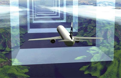
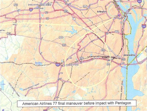
The WAAS signal also made possible under
autopilot control, the 370 degree decending right turn from an
altitude of 7,000 feet, performed by American Airlines flight 77
prior to its reported impact with the Pentagon building in
Arlington, VA on September 11, 2001.
Stanford University, 1998:
The Wide Area Augmentation System (WAAS)
... allows pilots to fly ... approaches that cannot necessarily
be flown with current instrumentation ... Complex curved
approaches, including approaches turning to a short (less than
one mile) final ... Pathways were constructed from ... climbing,
or descending constant radius arcs ... Autopilots could use WAAS
position and velocity to fly curved trajectories.
http://waas.stanford.edu/~wwu/jennings/publications/ION98/iongps98.pdf
In October of 2001, Cubic Defense Systems
applied for a U.S. patent for a system that utilizes GPS guided
aircraft autopilot systems to implement a programmed or remotely
transmitted flight plan, that overrides pilot control of an
aircraft and navigates it to a given destination.
Responsive to the override input, the
manager deactivates on-board control of selected aircraft flight
systems and the autopilot system, and directs the autopilot to
fly the aircraft ... In planning the flight routing ... the
manager may utilize ... GPS direct routing.
http://patft.uspto.gov/netacgi/nph-Parser?Sect2=PTO1&Sect2=HITOFF&p=1&u=...
Plausibility Of 9/11 Aircraft Attacks
Generated By GPS-Guided Aircraft Autopilot Systems
http://www.journalof911studies.com/volume/2008/AutopilotSystemsMonaghan....
FBI Claims
To Investigate Pre-9/11 GPS Theory
In a letter signed by Michael J.
Heimbach, Assistant Director of the Federal Bureau of
Investigation's (FBI) Counterterrorism Division, National
Security Branch, it is claimed that a hypothesis regarding
exclusive GPS guided autopilot control of the four aircraft
destroyed during the terrorist attacks of September 11, 2001 is
under review. The FBI notice is in response to receipt of a
twenty page thesis describing the aircraft attacks of September
11, 2001 being potentially within the capability solely of
autopilot and navigation systems of American Airlines and United
Airlines Boeing 757 and 767 aircraft and upgraded Global
Positioning System (GPS) technology circa 2001.
|