|
|
|
March / April 2011 Earthquakes |
|||||||||||||||||||||||||||||||||||||||||||||||||||||||||||||||||||||||||||||||||||||||||||||||||||||||||||||||||||||||||||||||||
|
Investigating The Concentrated Greenbrier, Arkansas Activity |
|||||||||||||||||||||||||||||||||||||||||||||||||||||||||||||||||||||||||||||||||||||||||||||||||||||||||||||||||||||||||||||||||
|
Levee Explosion Floods New Madrid Fault
Zone The Army Corps of Engineers has purposefully breached a hole in the Birds Point levee near Wyatt, Missouri. The destruction of the levee was an alleged attempt to prevent further flooding for nearby small towns, but instead may very well now have endangered millions more people. By strategically flooding 200 square miles of farm and swampland, the risk of earthquakes may now rise in the precarious New Madrid fault zone. It is an established fact that new large bodies of water, such as man-made dams, can cause earthquakes, due to the increased weight and movement of the water. NewsFocus has been corresponding since mid-March with retired USGS geologist Jim Berkland, the only person to predict the large 7.1 San Francisco World Series earthquake. Berkland maintains that large bodies of water, such as those created by dams, do in fact cause earthquakes. At a time when the U.S. government is preparing for a major catastrophic New Madrid earthquake with their FEMA NLE 2011 drills, one has to question the logic used in purposefully flooding the New Madrid area with such a huge expanse of water. To top it all off, they are considering the bursting of more levees as well. It is interesting to note that during the huge "500 year flooding" of 2008 and 2009 that this type of drastic effort was not needed. What makes 2011 so different from those huge flood years? It is true that an enormous amount of levees burst on their own during those floods, but this year is no comparison to '08 and '09, so why the intentional bursting of levees now, to flood the New Madrid area?
NewsFocus has already been studying the increased seismic activity taking place in Greenbrier, Arkansas. An inordinate number of quakes has been taking place within a very tiny tract of land there, and it has understandably caused grave alarm for the local residents. Allegations of HAARP signatures showing up on local weather radars drew more attention to the area, however, this reporter's investigation has also turned up much oil and gas fracking in this now unstable area. A recently discovered fault line there connects to the infamous New Madrid quake zone, making Greenbrier a potential trigger point for the New Madrid fault. In light of the voluminous historic earthquake and seismic activity taking place around the world, NewsFocus has requested that Congress enact a full drilling moratorium on fracking in the area, until more detailed studies can be done to understand its affect regarding the large number of quakes that have hit the area. A 4.7 earthquake was recorded there on February 28th of this year, as well as 4.0 and 4.2 quakes on April 7th and 8th, less than 24 hours from each other. (see table below on this page). There were 45 earthquakes in less than three days in the Greenbrier area. With all of the above in mind, this reporter finds the logic behind flooding 200 square miles area of land in the New Madrid area to be myopic, if not outright reckless. We appear to be preparing for earthquake disaster, while at the same time increasing its likelihood. NewsFocus questions the impetus of the long planned FEMA NLE drill, since the New Madrid region has been the only sizable fault zone in the world to remain stable during the pandemic global earthquake activity. As a matter of fact, if you take Greenbrier out of the equation, then there is no tenable threat to warrant such a massive exercise by the government. Many have questioned why FEMA would be stockpiling MREs, emergency blankets, and body bags for a mere drill. Word is also circulating that the Government Procurement Office (GPO) is also seeking over a quarter-million detainee handbooks. Again, why the sudden rush for tangible disaster goods if this is just a drill? People have good reason to question the impetus of these moves, along with the massive NLE 11 disaster "drill," in light of the fact that the U.S. and Great Britain were both planning for huge terrorist "drills" on the exact day that they coincidentally happened (9/11 and 7/7). And now we see FEMA preparing for a massive earthquake in the New Madrid zone on the 200th anniversary of the last large quake, even though the fault is thought to trigger every 300 to 350 years. To force such a huge body of water onto the New Madrid area at this time is, again, a reckless endeavor on the part of the U.S. Army Corps of Engineers. Combine that with the tectonic destabilization caused by fracking in central Arkansas, along with 15 nuclear reactors in the New Madrid fault zone, and you have a formula for disaster. It would appear that FEMA's NLE 11 is fraught with many questions. If Homeland Security was truly put in place to tie government agencies together, then they need to be questioned regarding NLE 11 and the Army Corps of Engineers deliberate flooding of the New Madrid area. We cannot say with certainty that a large quake will occur in the New Madrid fault zone, however, at this time of unprecedented tectonic activity, by allowing continued fracking, along with massive flooding of the New Madrid area, it would appear that our government is not taking their own FEMA NLE drill to heart, but is instead further exacerbating a potential disaster and clearly rolling the dice on a major earthquake. With the Rockefellers and Bush's buying up property in South America, it makes many wonder if there is an impending false flag disaster coming for North America. Stay tuned, be informed and be prepared.
Missouri Attorney General Asks Supreme
Court To Stop Levee Destruction Video: See the town of Cairo that was supposedly worth all of this risk. See also: Is Eco-Weaponry Trying To Tip The New Madrid Fault Zone? Is Eco-Weaponry Responsible For Weather Radar Anomalies?
HAARP Site Is Back Up, But Mysteriously Missing Key
Data With all the allegations of eco-weaponry making the rounds across the internet, it was most interesting to see the HAARP website and all of its data collection instruments suddenly go missing. It would appear that rather than address the myriad allegations regarding HAARP and increased earthquake activity, the site was simply taken down. This did nothing to refute the claims being levied of man-made earthquakes, but rather fueled the fire with those pointing the finger at the technology.
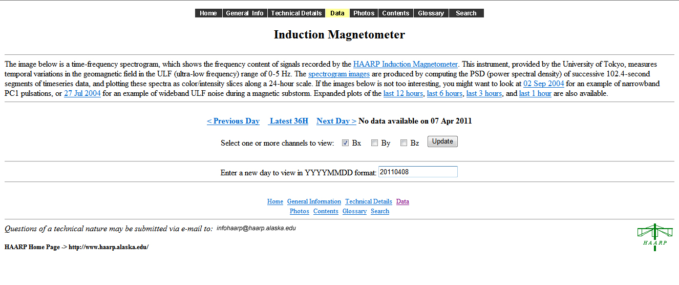
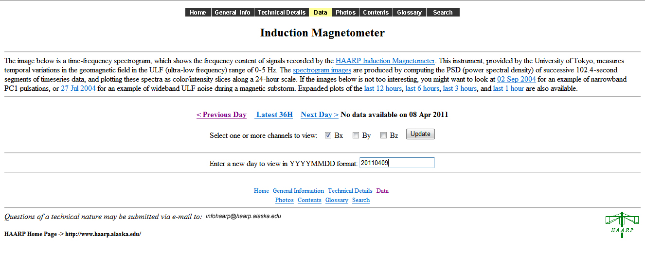
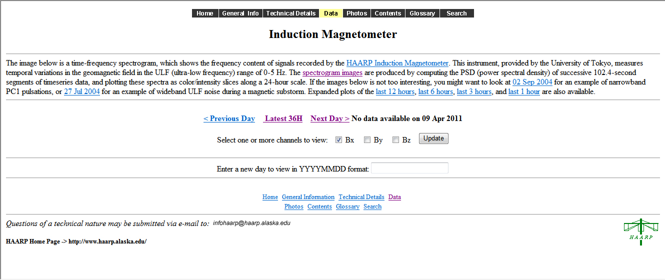
Now that the site is back up this reporter has noticed that the
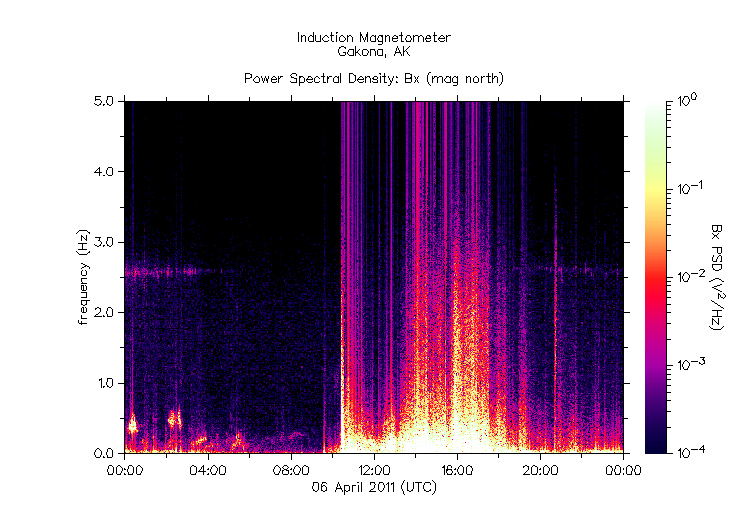
Gakona magnetometer readings are strangely enough missing after April 6th. The
magnetometer does not become active again until April 13th at roughly 1700
hours. (5pm) The 7th, 8th and 9th of April were when the Greenbrier earthquakes suddenly bounced through the roof with 45 earthquakes in just under three days (65 hours), all contained within a very tiny tract of land no more than 7.5 miles long and no more than 2.5 miles wide. (See original story farther below.) This missing data can only fuel the rampant speculation that abounds regarding possible nefarious use of the technology in stimulating existing tectonic stress and generating seismic activity. The last reading from the magnetometer was from April 6th, the day before the Greenbrier area was lit up with an inordinate amount of earthquakes. The magnetometer data can be found below.
April 6th (Click on picture for larger image)
April 7th (Click on picture for larger image)
April 8th (Click on picture for larger image)
April 9th (Click on picture for larger image)
Greenbrier Arkansas Seismic Activity Suddenly Way Up Greenbrier, Arkansas continues to hold the the most earthquakes within the smallest tract of land and has been the source of much concern. With many alleging nefarious meddling from eco-weaponry, such as HAARP, the official website for the HAARP station was mysteriously pulled down two days prior to the latest Greenbrier quakes. Update - 04/10: The Greenbrier quakes have been downgraded by USGS to a 3.9 magnitude. This is not unusual for them to do. A USGS geologist has recently told NewsFocus that many times earthquakes are downgraded for 1) insurance reasons, 2) regional and local economics, and 3) to suppress fear. So much for government integrity in reporting disasters. (Note: the smaller quakes have not been downgraded, only the larger quakes.) Update - 04/08: At a time when the HAARP website and its companion data page have mysteriously gone down, the earthquake activity in Greenbrier, Arkansas has suddenly gone way up. The area has encountered two 4+ quakes in the last twelve hours, with seismic frequency increasing dramatically.
09:56:00 a.m. Friday April 8, 2011
in
US/Central converts to
06:11:00 p.m. Thursday April 7, 2011
in
US/Central converts to
Stay tuned. More to come. Update: It appears that many magnetic observation stations are mysteriously inaccessible. The Kiruna Magnetic research page will only show data from April 3rd, but nothing recent. NewsFocus cannot retrieve data from the UCLA ground magnetometers either. We are currently checking all known world magnetic research sites. More info to come.
HAARP Data The USGS site has somehow fallen behind listing the most quake data on their website page showing seismic activity for the last 8 - 30 days. It currently ends on March 31st, however, you can get data for specific regions, if you look elsewhere within USGS. | Honshu, Japan | Greenbrier, Arkansas
Update: After a 7.4 Japan quake, and a 4.0
Greenbrier, AR quake on Thursday, April 7th, the HAARP data page has
strangely enough been blocked, or temporarily pulled. The timing of this "glitch" is
highly questionable. With all of the myriad allegations floating about HAARP and
earthquakes, this gives the impression that data is now being hidden, or
possibly doctored until it can be put back up. To see this happen in conjunction
with these already highly questionable quake areas is extremely disconcerting,
to say the least. Why not just post an explanation and thus challenge those
making claims of a HAARP connection? To just pull the site gives the wrong
impression at a time when many are concerned about the possibility of
"eco-weaponry" in the wrong hands.
What The Heck Is Going On In Greenbrier Arkansas? Update: Weekend provides two more quakes in Greenbrier. Arkansas papers report fracking as the cause, but fail to ask the bigger questions. Greenbrier is not the only fracking site in America. Secondly, who is allowed to deep drill without a USGS survey? Third, if indeed fracking is responsible, and this does cause calamity for the New Madrid area, who will be held responsible? More to come soon... NewsFocus has been tracking world earthquake data since early last week, long before the Honshu, Japan 9.1 quake. Using computer software with near real-time data from USGS, it has been possible to track and trend the earthquake data, while denoting location, depth and strength. The frequency of quakes within specific regions has been most notable and appears as an indicator of tectonic hot spots. Some of the most alarming hot spots to watch for in the U.S. are...
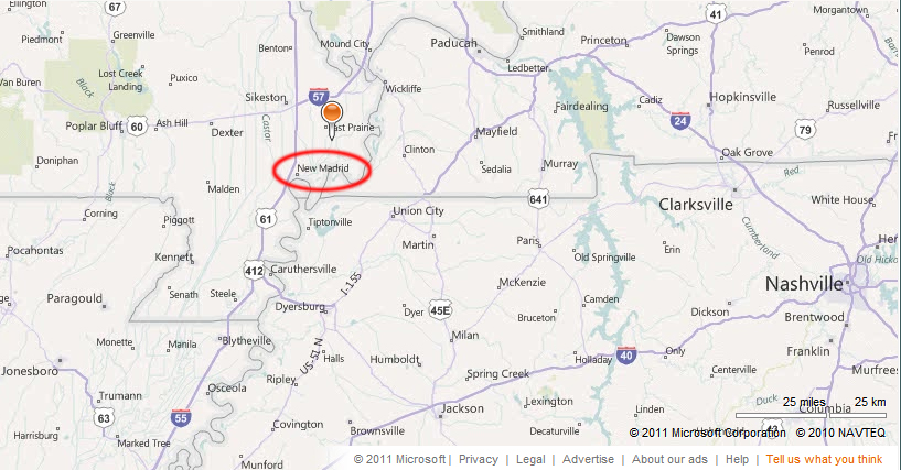
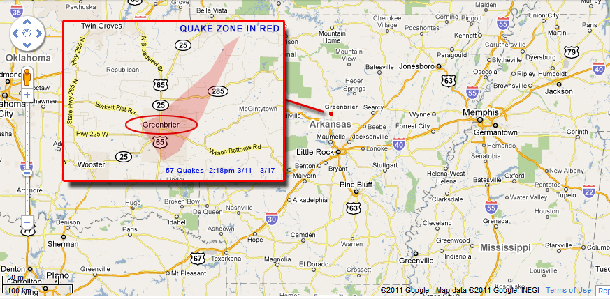
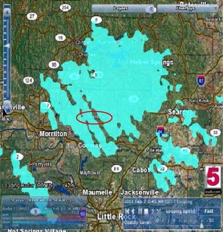
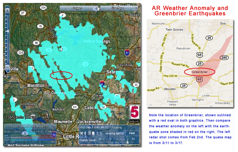
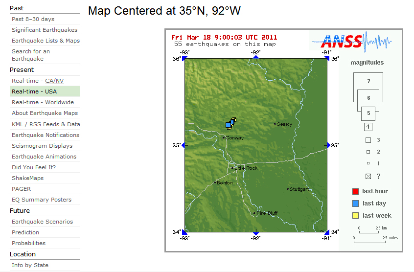
Honshu, Japan is obviously the hottest spot in the world by far, hands down. With that infamous distinction in mind, the next hottest area under threat has to be the southern coast of Alaska, which is off the charts with the most activity, next to Japan. It is arguably one of the most volatile areas right now and has to seriously be considered as a candidate for a large earthquake. The Gulf of California has had the most significant quakes with the highest magnitudes in a concentrated area, and could play a major role in triggering quakes for northwest Mexico and southwest U.S. There is one extremely curious area of note though that holds a unique distinction, Greenbrier, Arkansas, just 43 miles north of Little Rock. This tiny town of roughly 4,500 people has had more concentrated earthquakes within a very small, extremely focused area, than anyplace else since the Japan 9.1 quake. Greenbrier has had hundreds of minor quakes within a triangular area no wider than 2.5 miles on the south end and barely half a mile on the north end. In all, the small tract of land measures roughly 7.5 miles long. The most recent quake activity started on Friday, March 11th at 2:18pm with a 2.6 magnitude just four miles below the surface. The largest quake to date has only been a 3.0, which struck on Thursday the 17th, but the fact that this small area has had such a focused array of tectonic jolts is intriguing indeed. What becomes most intriguing is when you compare the map of this recent quake activity with a popular YouTube video making the rounds on the internet. Some have speculated about nefarious activity in the region, and this particular video was attempting to corroborate those suspicions. I had run across the video recently, but didn't have anything to make of it, until now. In tracking the outrageous amount of U.S. earthquake activity since the Japan quakes, I was making an earnest attempt to possibly spot the most likely spot where a major quake might start. I was scanning the data for trends when I came across the Greenbrier site. What I saw made me take a breath and sit back in near shock. I had remembered the YouTube video that I ran across a week earlier. I immediately did a frantic search and pulled the video back up to compare the data. My jaw literally dropped open. It was a perfect match. As a matter of fact, you couldn't get any more precise. An absolutely uncanny perfect match. In light of the claims being made by the poster, this gave me a pretty eerie feeling for quite some time. It still does. To be clear, the weather anomaly is from the month previous, February 2nd. The quake activity is from March 11th - 18th. The contention is that a common high-tech device is responsible for both images, and has allegedly been projected onto the area for an extended duration. Many speculate that this is secret Tesla technology at work. Whatever the cause, this is something for the scientific community to ascertain. It could be an as yet undiscovered natural anomaly, indicative of building tectonic stresses deep within the earth. Lightning is known to have a ground to sky connection. Is it possible that this is a force of nature, a harbinger of building tectonic forces, or could perhaps Melvin 8865 be correct in his assumption? It's hard to discount the absolute perfect match of the two maps. It means something. What that is, this author cannot say with any sure certainty, but it is undeniably something that definitely needs some further scientific scrutiny. In the interim, it would probably be a good idea for all those reading this to download this video from YouTube for further research, just in case it should end up getting pulled down. You can do this many ways, but one that is the easiest is the site KeepVid. You might also save this specific webpage as well, just in case this site has unexpected server issues. Go to "File"...then "Save As" to save a copy for yourself. There is also a zip file here that contains all of this info as well. One thing the internet certainly loves is a good mystery. Well here's a good one for you folks. Have at it!
The Tiny Red Dot North of Little Rock Shows Greenbrier, Arkansas
The mysterious phenomenon match from YouTube
A Good Side-By-Side Comparison The fact that these two maps pinpoint Greenbrier is one heckuva coincidence. The red shaded area of dense earthquakes fits perfect, centering neatly right inside this storm anomaly. It is amazing that someone could allege that Tesla technology is being used in this area, and then earthquake data would appear four weeks later that would tend to support that theory. The three diagonal swaths extending through the storm cloud, and right through Greenbrier, are said by many to be the fingerprint of Tesla technology at work. The only thing this author will say is, the map coincidence is indeed striking and very peculiar indeed. Again, a one in a million coincidence, or is it signs of advanced technology at work? This deserves further scientific evaluation. To have such a perfect match is eerily uncanny. This is something that USGS and meteorologists should be interested in.
The USGS Map Showing The Greenbrier
Earthquakes USGS Quake List - Greenbrier Area
Strange Radar Anomaly -
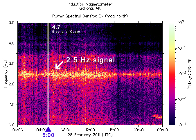
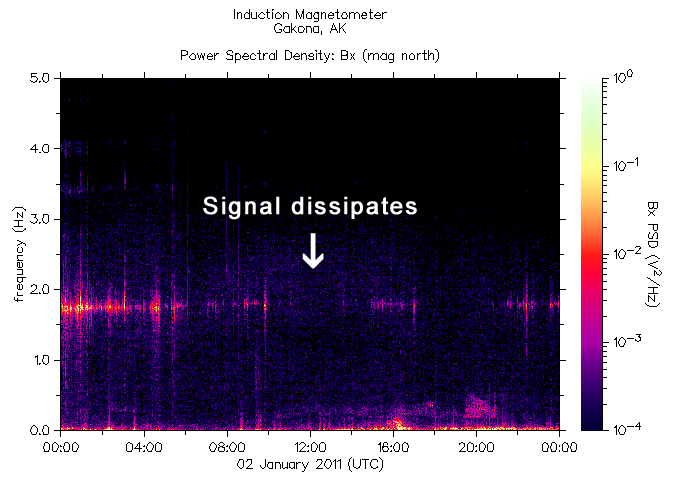
February 2nd, 2011 Thousands of dead birds and fish in Arkansas leave many scratching heads Video: CNN: Dead birds fall from sky in Arkansas Video: CNN: It's raining birds Feb 28 Greenbrier, AR 4.7 Quake This mysterious 2.5 Hz signal also showed up on February 27, 28 and 29 before vanishing again.
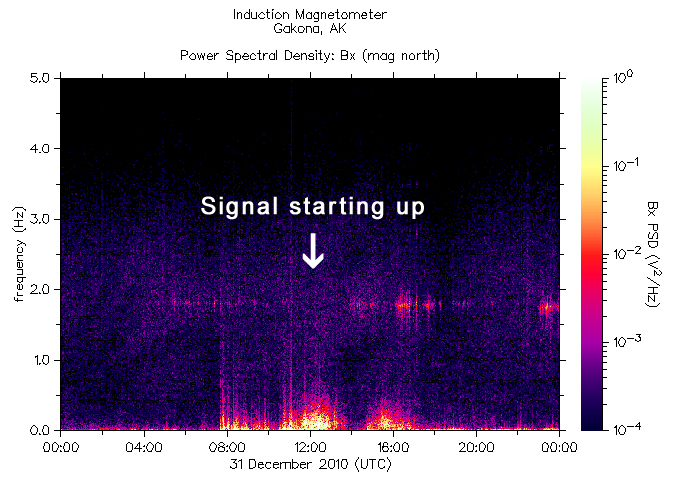
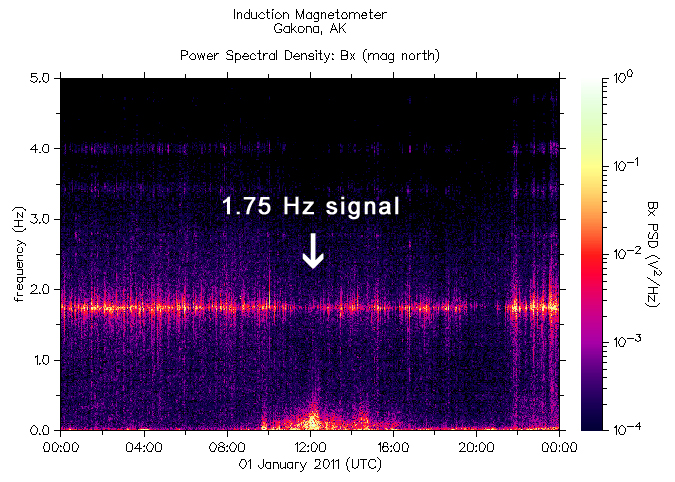
Beebe, AR Dead Birds 12/31/10 - 01/01/11 The mystery signal, although lower in frequency, was present just before New Years Eve, into New Years, and once again disappearing quickly the next day. 5,000 dead birds fell from the sky on New Years Eve over Beebe, Arkansas, next door to newly quake prone Greenbrier.
Return to
NewsFocus.org |